![](/images/other/stat-length.png)
![Tocht Stappen Deiva Marina - Séjour Cinque Terre - Journée 1 - Deiva Marina - Bonassola - Photo](https://media.geolcdn.com/t/1900/400/ext.pjpeg?maxdim=2&url=https%3A%2F%2Fmedia.geolcdn.com%2Ff%2Fb24c6297-dd4b-4ed9-b39c-778da18fcabf.jpg)
Séjour Cinque Terre - Journée 1 - Deiva Marina - Bonassola
chessyca
Gebruiker
![Lengte](/images/other/stat-length.png)
Lengte
23 km
![Max. hoogte](https://static1.geolcdn.com/siteimages/upload/files/1508320355ic_sort_altitude_max_24dp.png)
Max. hoogte
314 m
![Positief hoogteverschil](https://static1.geolcdn.com/siteimages/upload/files/1508320355ic_sort_den_pos_24dp.png)
Positief hoogteverschil
809 m
![Km-Effort](/images/other/stat-length.png)
Km-Effort
34 km
![Min. hoogte](https://static1.geolcdn.com/siteimages/upload/files/1508320355ic_sort_altitude_min_24dp.png)
Min. hoogte
0 m
![Negatief hoogteverschil](https://static1.geolcdn.com/siteimages/upload/files/1508320355ic_sort_den_neg_24dp.png)
Negatief hoogteverschil
809 m
![Boucle](https://static1.geolcdn.com/siteimages/upload/files/16400158638029165_repeat_loop_refresh_sync_direction_icon.png)
Boucle
Neen
Datum van aanmaak :
2021-09-27 15:13:23.732
Laatste wijziging :
2021-09-27 19:40:12.645
![Stappen](https://static1.geolcdn.com/sitytour/trail-icons/101.png)
--
Moeilijkheid : Medium
![Scan deze QR-code om de tocht te openen in de SityTrail-applicatie](https://capi.geolives.com/qq0zvz2zws4bq2lad0pu/sitytour/trails/2951558/qr.png?size=200)
Gratisgps-wandelapplicatie
Over ons
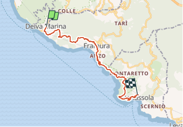
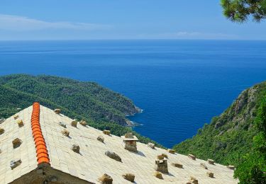
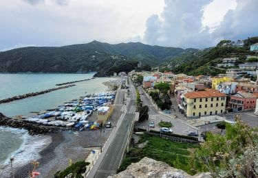
Tocht Stappen van 23 km beschikbaar op Ligurië, La Spezia, Deiva Marina. Deze tocht wordt voorgesteld door chessyca.
Beschrijving
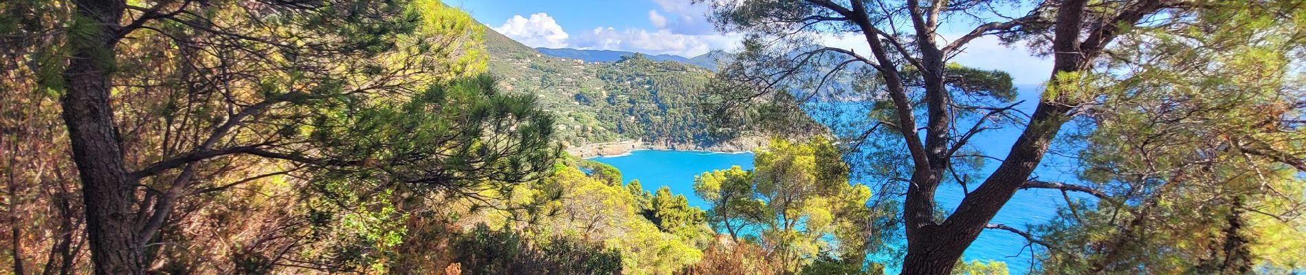
Les cinque terre et le golf des poètes par Chemins du sud
Première journée du séjour 2021 - Groupe 3
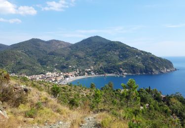
Train de Moniglia à Deiva Marina
Pause du midi à Framura.
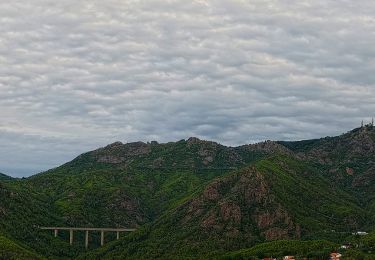
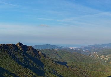
Journée de mise en jambe sans difficultés notables à signaler
Plaatsbepaling
Land:
Italy
Regio :
Ligurië
Departement/Provincie :
La Spezia
Gemeente :
Deiva Marina
Locatie:
Unknown
Vertrek:(Dec)
Vertrek:(UTM)
541589 ; 4896217 (32T) N.
Opmerkingen
Wandeltochten in de omgeving
![Tocht Te voet Bonassola - Reggimonti - Monte Gaggi - S.P. 64 - Monte Grumo - Photo](https://media.geolcdn.com/t/375/260/ext.jpg?maxdim=2&url=https%3A%2F%2Fmedia.geolcdn.com%2Ff%2F53b7c24f-114d-496d-8324-7d9132d796d3.jpeg)
![Te voet Te voet](https://static1.geolcdn.com/sitytour/trail-icons/100.png)
Reggimonti - Monte Gaggi - S.P. 64 - Monte Grumo
Te voet
Gemakkelijk
Bonassola,
Ligurië,
La Spezia,
Italy
![](/images/other/stat-length.png)
3,7 km | 7 km-effort
1h 34min
![](https://static1.geolcdn.com/siteimages/upload/files/16400158638029165_repeat_loop_refresh_sync_direction_icon.png)
Neen
![Tocht Te voet Bonassola - Bonassola - Salto della Lepre - Pastorelli - Montaretto - Photo](https://media.geolcdn.com/t/375/260/ext.jpg?maxdim=2&url=https%3A%2F%2Fmedia.geolcdn.com%2Ff%2Fa7cea6e7-bc07-4258-9020-ad0c6abe0784.jpeg)
![Te voet Te voet](https://static1.geolcdn.com/sitytour/trail-icons/100.png)
Bonassola - Salto della Lepre - Pastorelli - Montaretto
Te voet
Gemakkelijk
Bonassola,
Ligurië,
La Spezia,
Italy
![](/images/other/stat-length.png)
3 km | 4,2 km-effort
57min
![](https://static1.geolcdn.com/siteimages/upload/files/16400158638029165_repeat_loop_refresh_sync_direction_icon.png)
Neen
![Tocht Te voet Framura - Vandarecca - Montaretto - Reggimonti – Bivio AV5T - Photo](https://media.geolcdn.com/t/375/260/ext.jpg?maxdim=2&url=https%3A%2F%2Fmedia.geolcdn.com%2Ff%2F433b5181-ce40-4552-b8f8-d309475f0ca2.jpeg)
![Te voet Te voet](https://static1.geolcdn.com/sitytour/trail-icons/100.png)
Vandarecca - Montaretto - Reggimonti – Bivio AV5T
Te voet
Gemakkelijk
Framura,
Ligurië,
La Spezia,
Italy
![](/images/other/stat-length.png)
6 km | 11,9 km-effort
2h 42min
![](https://static1.geolcdn.com/siteimages/upload/files/16400158638029165_repeat_loop_refresh_sync_direction_icon.png)
Neen
![Tocht Te voet Framura - Framura (Setta) - Costa - Rovereto - Castagnola - Monte Sant'Agata - Photo](https://media.geolcdn.com/t/375/260/ext.jpg?maxdim=2&url=https%3A%2F%2Fmedia.geolcdn.com%2Ff%2Ff566bb7c-3946-4951-b36b-20a42e298c78.jpeg)
![Te voet Te voet](https://static1.geolcdn.com/sitytour/trail-icons/100.png)
Framura (Setta) - Costa - Rovereto - Castagnola - Monte Sant'Agata
Te voet
Gemakkelijk
Framura,
Ligurië,
La Spezia,
Italy
![](/images/other/stat-length.png)
6,3 km | 12,3 km-effort
2h 47min
![](https://static1.geolcdn.com/siteimages/upload/files/16400158638029165_repeat_loop_refresh_sync_direction_icon.png)
Neen
![Tocht Te voet Moneglia - Sella Crocetta (Bivio SVA) – Salto del Cavallo – Baracchino – Monte San Nicolao - Photo](https://media.geolcdn.com/t/375/260/ext.jpg?maxdim=2&url=https%3A%2F%2Fmedia.geolcdn.com%2Ff%2F5ff27ab8-192d-41d8-9ca3-8d68829dd71b.jpeg)
![Te voet Te voet](https://static1.geolcdn.com/sitytour/trail-icons/100.png)
Sella Crocetta (Bivio SVA) – Salto del Cavallo – Baracchino – Monte San Nicolao
Te voet
Gemakkelijk
Moneglia,
Ligurië,
Genua,
Italy
![](/images/other/stat-length.png)
7,9 km | 14,2 km-effort
3h 14min
![](https://static1.geolcdn.com/siteimages/upload/files/16400158638029165_repeat_loop_refresh_sync_direction_icon.png)
Neen
![Tocht sport Deiva Marina - Randonnée dans le maquis à partir de Deiva marina - Photo](https://media.geolcdn.com/t/375/260/ext.jpg?maxdim=2&url=https%3A%2F%2Fmedia.geolcdn.com%2Ff%2F4ba32944-461c-4b07-b83f-8b86c40e2d5a.jpg)
Randonnée dans le maquis à partir de Deiva marina
sport
Heel gemakkelijk
Deiva Marina,
Ligurië,
La Spezia,
Italy
![](/images/other/stat-length.png)
13,7 km | 19,3 km-effort
Onbekend
![](https://static1.geolcdn.com/siteimages/upload/files/16400158638029165_repeat_loop_refresh_sync_direction_icon.png)
Ja
![Tocht Te voet Deiva Marina - Costa – C.se Vigo – Ghiaia - Photo](https://media.geolcdn.com/t/375/260/ext.jpg?maxdim=2&url=https%3A%2F%2Fmedia.geolcdn.com%2Ff%2Ff096ed62-e390-4fe7-b618-b699293dff67.jpeg)
![Te voet Te voet](https://static1.geolcdn.com/sitytour/trail-icons/100.png)
Costa – C.se Vigo – Ghiaia
Te voet
Gemakkelijk
Deiva Marina,
Ligurië,
La Spezia,
Italy
![](/images/other/stat-length.png)
3 km | 5,5 km-effort
1h 15min
![](https://static1.geolcdn.com/siteimages/upload/files/16400158638029165_repeat_loop_refresh_sync_direction_icon.png)
Neen
![Tocht Te voet Moneglia - sejour-cinq-terres-journee-1-decouverte-de-moneglia - Photo](https://media.geolcdn.com/t/375/260/ext.jpg?maxdim=2&url=https%3A%2F%2Fmedia.geolcdn.com%2Ff%2Fdb45af9a-684d-45c3-b432-53fd5a1e410f.jpg)
![Te voet Te voet](https://static1.geolcdn.com/sitytour/trail-icons/100.png)
sejour-cinq-terres-journee-1-decouverte-de-moneglia
Te voet
Gemakkelijk
Moneglia,
Ligurië,
Genua,
Italy
![](/images/other/stat-length.png)
4,1 km | 4,9 km-effort
1h 6min
![](https://static1.geolcdn.com/siteimages/upload/files/16400158638029165_repeat_loop_refresh_sync_direction_icon.png)
Ja
![Tocht Stappen Deiva Marina - Rando cinq terre 1er jour Deiva Marina - Levanto - Photo](https://media.geolcdn.com/t/375/260/ext.jpg?maxdim=2&url=https%3A%2F%2Fmedia.geolcdn.com%2Ff%2F323d459e-7953-4cf9-af66-e98b64590792.jpg)
![Stappen Stappen](https://static1.geolcdn.com/sitytour/trail-icons/101.png)
Rando cinq terre 1er jour Deiva Marina - Levanto
Stappen
Zeer moeilijk
Deiva Marina,
Ligurië,
La Spezia,
Italy
![](/images/other/stat-length.png)
16,8 km | 28 km-effort
5h 26min
![](https://static1.geolcdn.com/siteimages/upload/files/16400158638029165_repeat_loop_refresh_sync_direction_icon.png)
Neen